


Visitors to Fall River today may know Quequechan Street without ever stopping to ask what “Quequechan” means. The name comes from the language of the Wampanoag people and means “falling water,” a reference to the river and its series of waterfalls that gave the city its name.
But there is an irony in that history. The river that gave Fall River its identity is now largely hidden beneath roads, highways, and the modern city.
In reporting by The Public’s Radio, retired Fall River town planner and historian Al Lima reflected on that irony: “Fall River’s called Fall River, but there’s no falls in Fall River. We don’t see the falls.” Lima, who has written about Fall River and its relationship with water, has spent years examining how the river shaped the city’s history.

That was not always the case.
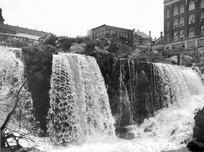
The Quequechan River is only about 2.5 miles long, flowing from the interior of Fall River toward the Taunton River and Mount Hope Bay. Near what is now downtown, the land drops sharply, creating a series of small waterfalls and rapids. Originally, there were eight such falls along the narrow stream between present-day South Main Street and the tidal waters of the Taunton River.
For the Wampanoag people, the falling water was a natural landmark. For the settlers and industrialists who came later, it became something even more valuable: a source of power.
In 1813, the establishment and expansion of Fall River Manufacturing marked an important turning point. The river’s steep descent could be harnessed to power machinery, helping transform a small community into one of America’s great textile centers. Dams were constructed, the upper river was altered to create additional water storage, and textile mills increasingly occupied the banks and covered portions of the river.
During the first half of the 19th century, the Quequechan became inseparable from Fall River’s industrial development. Water that had once tumbled freely through the landscape was redirected through mill systems, while factories grew around it.
By the early 20th century, Fall River had become a textile powerhouse. By 1910, the city was producing more textiles than any other American city. Its mills consumed enormous quantities of water, and contemporary accounts marveled at the scale of industrial production. The river that had once defined a natural landscape had become an essential component of an industrial machine.
Yet industrial prosperity came with a cost.
As Fall River expanded and its population surpassed 100,000, the Quequechan became increasingly polluted and diminished. During hot summer months, its flow could become low and sluggish. Industrial wastes, hot water discharged from the mills, human waste, and other refuse entered the river. A city dump was also located along its course.
By 1913 and 1914, conditions had become serious enough that the city undertook a formal investigation. The Quequechan River Report, published in 1915, documented concerns about the river’s flow, water quality, and sanitary condition. The very resource that had helped make Fall River prosperous had become an environmental and public-health problem.
The river’s transformation continued in the 20th century.
During the 1960s, construction of Interstate 195 radically altered the landscape. The highway was built along much of the Quequechan’s course. West of Plymouth Avenue, portions of the river were enclosed in underground box culverts. Farther east, sections of the former mill pond were filled to create the highway embankment. Portions of Interstate 195 and Route 24 were constructed directly over or alongside the river.
The Quequechan had, in effect, disappeared from public view.
Today, much of the river still runs unseen beneath the city and its transportation infrastructure. What was once a defining feature of the landscape has become something many residents pass over without realizing what lies below.
Yet the river has never completely vanished. Its waters still follow the ancient course that shaped Fall River’s history. The abandoned railroad corridor and bike path parallel portions of the buried river, offering occasional reminders of the landscape that existed before the highways.
There have also been recurring efforts to restore the Quequechan to public view, particularly the historic falls near downtown. The idea is more than an environmental project. It is an attempt to reconnect the modern city with the natural feature that gave it its name.
The story of the Quequechan is, in many ways, the story of Fall River itself: a landscape transformed by industry, prosperity built upon water, and a natural resource gradually hidden by the city it helped create.
The next time someone sees Quequechan Street, the name may prompt a different question. Not simply What does Quequechan mean? but Where is the falling water?
The answer is that it is still there—flowing beneath Fall River, carrying with it a history that predates the mills, the highways, and the city itself.
Portions of the historical background and quotations from Al Lima in this article are based on reporting by The Public’s Radio.